The Atlantic hurricane season begins June 1 and ends November 30. Peak hurricane season is between August and October.
Hurricanes are not just coastal problems. They can affect residents along the major rivers and waterways in Southwest Florida to Lake Okeechobee.
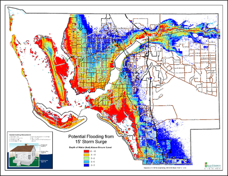
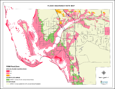
There are specific risks associated with hurricanes such as wind, tornadoes, heavy rainfall and storm surge. Of these, the greatest risk to life is posed by storm surge and rainfall flooding.
Storm Surge
Storm Surge is an abnormal rise of water generated by a tropical storm or hurricane. As these storms make landfall, they produce water level rise and strong winds that push water into shore. Storm surge forecasts do not account for large crashing waves or debris in the water.
Due to low elevation and proximity to beaches and other tidal waters, storm surge can travel far inland in Lee County.
Flooding
Heavy or prolonged rain can result in flooding. Prolonged rainfall saturates the ground and less of the water can be soaked up. Heavy rainfall can have less of a chance to be soaked up by the soil.
'Sheet flow' is a natural flow of water south through the Florida peninsula and may cause flooding along rivers, creeks and canals.
Need to Know
- Foundations of homes may fail.
- Standing water may contain debris, chemicals, and raw sewage.
- Electricity may be out – potentially for a long time.
- Tap water may be unsafe for drinking, bathing or cooking.
- Roadways & bridges may sustain heavy damage, be covered in water and/or debris.
- Flood waters may contain debris, chemicals, and raw sewage.
- Electricity cannot be restored with high water levels surrounding homes.
- Well water may be unsafe for drinking, bathing or cooking.
- Septic tanks may fail or become damaged.
- Young children and animals can drown, be injured, or become severely ill from playing or swimming in flood waters.
- Be Prepared, Stay Safe, Stay Dry!
|
|